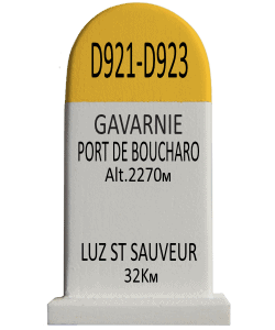
Gavarnie-Port de Boucharo – Luz St sauveur
€ 9,00
Beschrijving
The Puerto de Bujaruelo (French: Port de Boucharo) is a mountain pass over the main ridge of the Pyrenees on the border of the French department of Hautes-Pyrénées and the Spanish region of Aragon. The name refers to the Spanish hamlet of Bujaruelo (Castilian) / Buixaruelo (Aragonese) located on the west side of the pass. The pass is located in the central Pyrenees, just northwest of the Pic du Taillon.
Unlike the famous Brèche de Roland that lies above the Cirque de Gavarnie, the Port de Boucharo connects to Gavarnie via the nearby valley of Pouey Aspé, into which the Gave des Tourettes flows. This mountain stream feeds the Gave de Gavarnie, a tributary of the Adour via the Gave de Pau. The southwest side of the pass belongs to the basin of the Río Ara, a tributary of the Ebro.
Extra Info
| Weight | 0,110 kg |
|---|---|
| Dimensions | W 43mm x D 34mm x H 77mm |