Bonette – Restefond Route
€ 9,00
Beschrijving
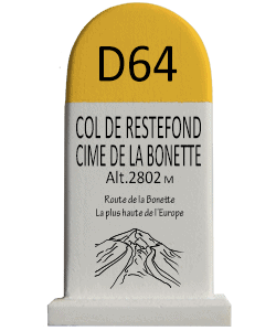
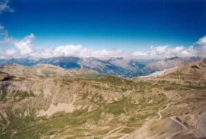
TheCol de la Bonette is a 2715 meter high pass in the French Alps situated in the Marcantour National parc.. The road forms a link between Jausiers (near Barcelonnette) and Saint-Étienne-de-Tinée.
The two-kilometre road rounds the Cime de la Bonette, a side road from the Col de la Bonette, is one of the highest paved roads in the Alps.e twee kilometer lange weg rond de Cime de la Bonette The road reaches an altitude of 2802 metres and is often classified, wrongly, as the highest paved road in the Alps, but Austria’s Ötztaler Gletscherstraße reaches 2829 metres and is thus higher. The road around the Cime de la Bonette is not strictly speaking a col either, but it is the highest point in the Alps accessible via two different roads. Outside the Alps, in Spain’s Sierra Nevada, the Pico Veleta can be climbed from the north side via a paved road to a few meters below the summit with a height of 3396 meters. This road is closed to motorized traffic.
Original uploader was Calips at fr.wikipedia – Transferred from fr.wikipedia; transferred to Commons by User:Zil using CommonsHelper., CC BY-SA 1.0, https://commons.wikimedia.org/w/index.php?curid=6018731
Extra Info
| Weight | 0,120 kg |
|---|---|
| Dimensions | W 43mm x D 34mm x H 77mm |