Cime de la Bonette – Jausiers
€ 9,00
Beschrijving
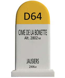
The Col de la Bonette is a 2715-meter-high mountain pass in the French Alps located in the Mercantour National Park. The road forms a link between Jausiers (near Barcelonnette) and Saint-Étienne-de-Tinée.
The two-kilometer road around the Cime de la Bonette, a side road from the Col de la Bonette, is one of the highest paved roads in the Alps. The road reaches an altitude of 2802 meters and is often classified, incorrectly, as the highest paved road in the Alps, but Austria’s Ötztaler Gletscherstraße reaches 2829 meters and is thus higher. The road around the Cime de la Bonette is also not strictly speaking a col, but it is the highest point in the Alps that can be reached by two different roads. Wikipedia
Extra Info
| Weight | 0,120 kg |
|---|---|
| Dimensions | W 43mm x D 34mm x H 77mm |