
Cime de la Bonette – St Etienne de Tinée
€ 9,00
Description
The Col de la Bonette is a 2715-meter-high mountain pass in the French Alps located in the Mercantour National Park. The road forms a link between Jausiers (near Barcelonnette) and Saint-Étienne-de-Tinée.
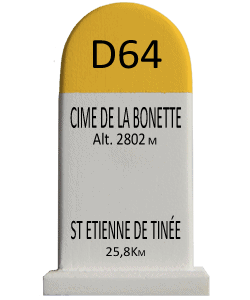
The two-kilometer road around the Cime de la Bonette, a side road from the Col de la Bonette, is one of the highest paved roads in the Alps. The road reaches an altitude of 2802 meters and is often classified, incorrectly, as the highest paved road in the Alps, but Austria’s Ötztaler Gletscherstraße reaches 2829 meters and is thus higher. The road around the Cime de la Bonette is also not strictly speaking a col, but it is the highest point in the Alps that can be reached by two different roads. Wikipedia
The Col de la Bonnette has now been part of the course in four editions of the Tour de France; in 1962, 1964, 1993 and 2008.
On July 22, 2008, the Tour de France passed the Col de Restefond and the Cime de la Bonette in the stage from Cuneo to Jausiers. The stage description refers to Cime de la Bonette-Restefond as the highest point of the Tour (2802 m). Strictly speaking, however, this point is called Cime de la Bonette. On Oct. 25, 2023, at the presentation of the course for the 2024 Tour de France, it was announced that the Col de la Bonette will return to the course for the first time since 2008 and will once again reach the point of 2802 m altitude. Wikipedia
Additional Info
| Weight | 110 kg |
|---|---|
| Dimensions | W 43mm x D 34mm x H 77mm |